platfaq
NC PLAT Field Data Collection FAQ
How far downstream can a pond exist and still claim credit for the pond as a BMP in PLAT?
The rule to use when assessing the eligibility of any of the PLAT BMPs is that the practice (pond, sediment basin, buffer, water table control structure) must either exist (or be plannend for) in the area between the land where the nutrients are applied and a perennial stream (or an intermittent stream with uninterrupted concentrated flow to a perennial stream). By definition, a perennial stream is one in which water flows or stands all year long in a normal year. If a perennial stream feeds the pond, then it cannot be included as a PLAT BMP.
Can credit be claimed for BMPs that are “planned” in the determination of the PLAT rating?
Generally, yes, because running PLAT is just a part of developing a nutrient management plan. A major benefit of the PLAT approach is that it can be used as a planning tool to identify needed BMPs that will reduce potential P losses. When BMPs are claimed in PLAT, either directly in the BMP section, or indirectly through the entry of a “planned” soil loss estimate, these are documented on the PLAT results printout. If the management or BMPs specified in PLAT do not exist at the time PLAT is run, then a conservation plan for the field(s) must be developed and include the identified practices. Similarly, if a soil erosion rate is entered in PLAT that is less than the existing soil erosion rate for the field, then erosion control practices must be included in the conservation plan that support the soil erosion rate specified in PLAT. All such “planned” BMPs credited in PLAT must be scheduled and installed during the first year of the nutrient management plan.
The exception to the use of “planned” BMPs in PLAT is when PLAT is run in response to the DENR requirement to run PLAT in preparation for the next NPDES permitting. Because a full nutrient management plan is not being developed at the same time, then the PLAT rating should be computed using existing conditions for the field.
The drainage spacing seems to make a big difference in the resulting PLAT rating.
How should the drain spacing be computed to ensure an accurate PLAT rating?
Dealing with artificially-drained fields can be confusing. This confusion exists primarily because of the diversity of soils and drainage classes that often exists within a single field. If the field is composed of soils that are all poorly drained or the field is entirely drained through artificial structures (open ditches, tile lines), then the planner should designate “YES” on the drainage question in PLAT, and the drain spacing and depth should be entered. For regularly-spaced drains, enter the distance between drains (in feet). For irregularly spaced drains, divide the area of the field (in square feet) by the linear distance of drains (both surface and subsurface) to obtain the drain spacing.
If only a portion of the field is poorly drained and requires artificial drainage, then the planner must decide whether subdividing the fields is appropriate. See the question and answer below for guidance on determining when subdividing fields is appropriate.
If the decision is to subdivide the field into two parts based on drainage class, then each portion must have PLAT analyzed separately. The drain spacing for the poorly drained portion of the field is computed using either of the procedures described above. For the portion of the field not requiring artificial drainage, designate “NO” on the drainage question in PLAT. If the decision is made not to subdivide the field, then the planner should answer the entire drainage question (YES/NO, drain spacing and depth) based ONLY on the drainage in the predominant portion of the field – not the entire field.
In summary: the drainage spacing should be calculated based only on the portion of the field that needs drainage.
What about fields that have only a perimeter ditch along one edge? How is drain spacing computed?
An open ditch may serve one or more purposes within a cropland setting. It may simply serve as an outlet for tile lines or other drainage structures, and exist only to convey water drained from upslope or nearby sites. It may also serve as an outlet for conveying surface runoff water away from a site to prevent ponding. A common example of this would be a roadside ditch that was installed to carry surface water from the roadway and adjacent land. The third function is to provide subsurface drainage for water moving laterally through the soil. From a drainage standpoint, open ditches should only be considered in PLAT when they serve to provide subsurface drainage.
In summary: if a single edge of the field ditch is the only artificial drainage, then this field would in most cases be considered undrained.
We know that the option exists for planners to subdivide fields for the purposes of running PLAT and developing the nutrient management plan. What is the guidance for determining when this should be done?
This question is one of the primary reasons that resource management planning is a professional activity. Soil properties, drainage class, land slope, drainage area and direction, and applicability of BMPs may all vary WITHIN any single field. Recording all this variability is not feasible. Thus, one of the first tasks of any resource planner is to decide when the conditions within an individual field are so diverse that the field should be subdivided for planning purposes, and when the “predominant” conditions in a field can be used to represent the entire field. As with RUSLE soil erosion computations, collecting soil samples, pest management planning, nutrient management planning, and of course, PLAT analyses all require professional judgment.
The planner should look at this in-field variability from two dimensions: 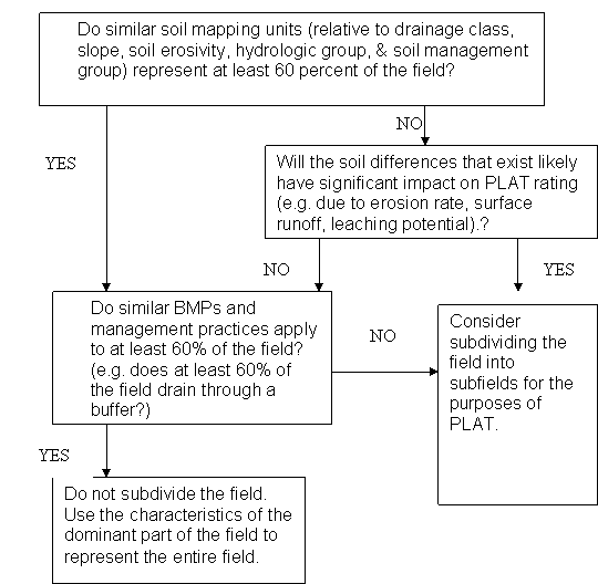 “areal extent” and “impact”. First, if the field is generally homogeneous, but only a small portion of the field is “dissimilar”, then generally it is advised to use the soil, drainage class, management, BMPs, etc from the predominant portion of the field to represent the entire field. Although there is no single “correct” threshold, fields should generally not be subdivided when the “dissimilar” areas represent less than 25 percent of the field.
The second dimension to consider is the “impact” from the variability within the field. For example, if the erosion rate calculated from the characteristics for half of the field is 4 tons/acre/year, and the other half of the field is eroding at 5-6 tons/acres/year, it would not be logical to subdivide the field into nutrient management subfields for PLAT. The erosion rate should be averaged for the field. If however, the second half was eroding at 12 tons/acre/year, then the field should probably be subdivided because there would likely be a significant impact on the resulting PLAT rating. By NOT subdividing, the entire field would likely be rated as high or very high, even though only half the field would really have a potential for excessive P loss.
In general, the two best site characteristics to use in assessing the need to subdivide fields are the variation in (1) soil mapping units, and (2) management and applicable BMPs within the field.
Note: This is simply one way of logically considering this decision. Whatever approach is used should be logical and defensible.
It should also be remembered that subdividing fields can be used as an optional planning tool to assist producers with high or very ratings to identify environmentally sound areas for waste application. Even if a decision was made to use the characteristics of the predominant part of the field to represent the entire field, and the resulting rating is HIGH or VERY HIGH, the planner may still want to consider a subdivision. The planner has the discretion to identify subfields that can realistically be managed separately, and run PLAT on the subfields separately. This may allow a producer in some cases to identify a significant portion of a field that will result in a low or medium rating.
The buffers between our cropland fields and the surface water is often not a regular width, and they vary in vegetation type, and even overland flow concentration. How should be determine buffer width and composition for PLAT purposes?
Generally buffer widths should be averaged for a field. Concentrated flow through a buffer defeats the filtering effect of the buffer. When a portion of a field drains through direct channel through the buffer, that portion of the field may need to be subdivided into a subfield for PLAT purposes. See the discussion and flowchart above on subdividing fields.
PLAT allows users to enter the width of buffer by vegetation type. For example, a common buffer in North Carolina would be a 20 ft vegetated buffer of grass and 15 feet of trees/shrubs. These are entered in PLAT as two separate buffers.
Does a buffer have to be immediately adjacent to a field to claim the buffer credit?
No. If the field drains through the buffer prior to reaching the surface water, then it may be counted, regardless of distance from the field. See question number 1. Planners should be cautious, however, of concentrated flow through the buffer.
When wetlands occur in buffers, should these be considered a surface water, and ineligible for credit as part of the buffer practice?
The answer is that it depends upon the type and location of the wetland. Obviously, it is not realistic or desirable to map all the wetlands in the buffer as part of the nutrient management planning process. The essential question is where do excessive nutrients moving from the field reach a perennial stream?
Planners should understand that PLAT provides no credit for a buffer in reducing soluble or leaching P losses, so the function of the buffer is for particulate P only — primarily P attached to soil particles in runoff. A recognized ecological function of a wetland where sufficient vegetation is present is the trapping of sediment and attached material. Similarly, in depressional wetlands within a buffer that have standing water through a portion of the year, there should be a particle-trapping function similar in concept to that identified for sediment basins. So simply meeting the criteria for being a wetland (hydrology, hydric soils, hydrophytic vegetation) should not in itself make a site ineligible to be considered part of a buffer.
An exception to claiming this particulate P reduction credit for wetlands within a buffer exists when the buffer includes a permanent or seasonally inundated wetland that is directly connected to a perennial stream. In this situation, the edge of the wetland essentially becomes the edge of the stream, at least for some period of the year. Since the buffer width for PLAT purposes is measured from the edge of the field (on which PLAT is being run) to a stream, this exception eliminates the unintended identification of the stream itself as a buffer.
In summary, wetlands vary in nature from site to site. If the wetland area of the buffer is seasonally inundated under standing water each year (not just periodic storm event flooding) — AND the inundated area includes (is directly connected to) a perennial stream, then the buffer width should only extend from the edge of the field to the estimated edge of the seasonally inundated stream/wetland. If a buffer area contains a depressional area that is inundated seasonally but NOT directly connected to a perennial stream, then the buffer width may include this wetland.
Once again, this determination requires professional judgement by the planner. The soils database does contain data by soil type on whether it is seasonally flooded and duration information, etc. that could be used in cases where it is questionable. The soils and topo maps do also include the identification of perennial streams.
A word of caution: Planners need to be aware of misperceptions that may be associated with this issue. Just as with any buffer, the wetland would not be considered part of the waste application area — waste is not applied in the buffer. In addition, the use of buffer BMPs in PLAT is not an authorization to over apply manure to the extent that direct runoff of the material occurs.
The receiving slope is difficult to determine on the flatter Coastal Plain settings. How should receiving slopes be determined on these sites?
To determine the length of the receiving slope, simply identify the lower end (toe) of the RUSLE slope. This is defined as either the edge of the field or where deposition starts within the field. The receiving slope is defined as the distance between this point (where deposition starts) and the edge of the field.
In general, the rule of thumb is that if a receiving slope is really difficult to identify when standing in the field, it probably (1) does not exist, or (2) will make such a small difference in the sediment delivery that it does not matter. (The sheet and rill erosion on slopes less than 3 percent is generally low.) If a receiving slope is not evident, do not report one.
Is there any guidance on the number and methodology for collecting deep samples when these are required?
Yes. There is a SoilFacts information sheet available on the NCSU nutrient management web page that contains guidance on the proper procedures for collecting deep samples to prevent contamination.
The number of samples required depends, just as with an agronomic sample, on the soil diversity within the field. Logistically, it is not realistic to pull the same number of deep samples as the agronomic sample; however, at least 5 samples per field should usually be collected. If there are significant differences expected in the texture of the subsoil material or nutrient application history within the field, it is advisable to separate these samples rather than submitting a single composite deep sample for the entire field. This provides flexibility in the planning process to subdivide the field if needed.
How long is the PLAT rating applicable? Does it have to be re-run every year, or when the plan is amended, or when the plan is revised?
A PLAT rating applies for the life of the nutrient management plan. USDA nutrient management policy specifies that nutrient management plans must be revised at least every five years, or earlier if revisions are needed due to changes in the operation. PLAT only needs to be run when the nutrient management plan is written or revised.
What is the policy on the 4” versus the 8” sampling depths for grassland and conservation tillage?
The soil sample to be used by PLAT should be the standard agronomic sample depth for the crop as recommended by NCDACS and NCSU. This is 8 inches for conventionally tilled crops, and 4 inches for pasture, hayland, and no-tilled crops.
If as a planner, you think the soils data mapped in a field is not correct or that the field is predominately composed of an inclusion(s) in the soil mapping unit, how should this be handled?
The soils data used by PLAT and the nutrient management plan should always be based on the soil mapping unit identified on the official NRCS soils map for the county, with the following exceptions:
If you think the soils data for the field being planned is not correct, then you should contact your NRCS Area Resource Soil Scientist to request assistance. An on-site soils investigation may be warranted in some cases. Except as indicated below, planners should always use the mapping unit identified on the official NRCS soils map.
If the field being planned falls on a portion of a soil mapping unit that is predominantly within a soil inclusion as listed and described in the official NRCS Soil Series Description for the county, then you may document this determination in the “Add Comments” feature of the PLAT print out. If this determination is made, it should also apply in the resulting nutrient management plan, and be documented accordingly. This option is intended to help overcome limitations in the use of soils maps due to the original mapping scale. Abuse of this option will result in bad things… very bad things.
If the soils in your county are currently being remapped and the newly mapped series is not yet available within the PLAT soils legend for the county, contact your local soil scientist. Procedures will be developed to accommodate these situations as quickly as possible.
What data may be used to estimate the nutrient application rates in PLAT?
PLAT requires the entry of the planned or estimated nutrient application sources by type, amount, and application method. This data is used to compute the potential source P transport off-site.
The material and amount specified in this section may come from an existing nutrient management/waste utilization plan, historical records, or in cases where neither exists, the type and amount of material that is tentatively planned to be applied to the site. The amount specified in the final nutrient management plan may not exceed the amount used to generate the PLAT rating for the site.
The P content of the material entered into PLAT may be derived from laboratory analysis, the default values that already exist in PLAT, or historical data. See the 590 NRCS Nutrient Management Standard for the criteria for specifying the nutrient values for animal waste to be applied.